ACESS AND APPROACHES
- DESCRIPTION
- PHOTOS
- ACCES AND APPROACHES
- CULTURAL EVENTS
- COUNTRYSIDE AND SPORTS
- PRICES
- REVIEWS
- CONTACT
- GITES DE FRANCE

Accès :
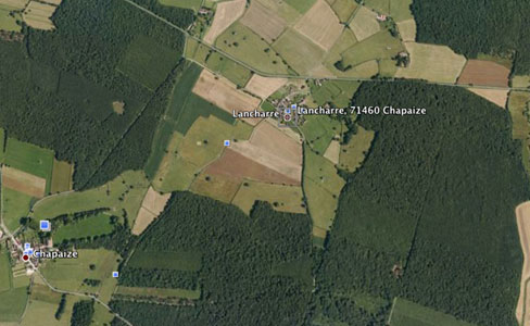
Longitude: 4.737 Latitude: 46.557 Altitude: 214mLeave the A6 motorway at Tournus. Follow the national road N6 (Tournus direction) for several minutes. Opposite the hotel ”le Rempart” turn right under the railwail bridge onto the D215 towards St Gengoux le National through Mancey and over the “Col des Chèvres” (pass of goats).
Drive 12,3 km from the railway bridge. Lancharre is on your left ans is easily seen from the D215 (a 2 storey building on the corner) Drive into the hamlet. Go into the square, the road runs past the front of the church. The tuilerie and the gite are 150 m beyond the church at the end of the road....
Total time from Tournus : 15 mins.
Geographic Localisation :
Lancharre is situated 2 km north east of Chapaize on local road D 215 from Tournus to St Gengoux le National. The hamlet is in open countryside near, but not at, the axis of the roads which unite Brançion Chapaize, Taizé and Cluny, at the heart of romanesque church tour.
Mode of Travel :
SNCF (national railways) : station at Tournus
TGV (high speed train,: stations at Montchanin (near Le Creusot) or Macon loché (35-45 min. drive)
Paris by TGV 1 hr 25
Saint Exupery Airport : near Lyon (1 hr ½ drive via motorway, heading north towards Paris)